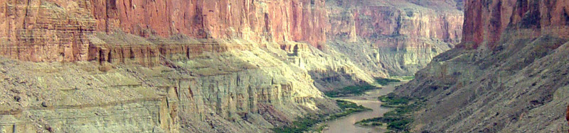
The Colorado River is the lifeblood of the southwestern United States and northwest corner of Mexico. From the high peaks of the Rocky Mountains in Colorado, through the desert canyons of Utah and Arizona, touching the borders of Southern Nevada and California, and finally flowing across the lowlands of Mexico and into the Gulf of California (also called the Sea of Cortez), the Colorado River is the primary water source for thousands of plant and animal species. While many of the species that are dependent on the flows of the Colorado River live within the channel of the river itself, others thrive on the vegetation that grows from the constant source of soil moisture provided by the river to the surrounding riparian area. In the vast desert of the American Southwest, the Colorado River provides nourishment for migratory birds passing through on their annual journey.
This unit describes the transformation of ecosystems as a result of water resource development of the Colorado River. We will focus on a few key regions that provide habitat for species that are now endangered and how choices that we have made over the last 80-years have impacted these regions. We will also discuss what efforts are being done to improve the habitat for these endangered species and what is not being done.
In this unit we will discuss:
Transforming Natural Hydrologic Flows to a Controlled System
Changes of Volume and Timing
Changes in Water Quality
General Impacts on Native Species
Current Management Policy for Instream Flows
Case Study 1: Upper Colorado Fish Recovery Program
Case Study 2: Lower Colorado Multiple Species Conservation Program
Case Study 3: Colorado River Delta
A Rapid Transformation
It is difficult for anyone today to comprehend what the Colorado River was like before its waters were dammed and diverted. Few quantitative records exist from before that period, but qualitative stories from explorers such as John Wesley Powell, who first traveled through the Grand Canyon by boat in 1869, paint a picture of immense grandeur with an untamed and unforgiving river running through it. Similarly Aldo Leopold wrote the following of his first experience through the Colorado River Delta: “… but in fact the river was nowhere and everywhere, for we could not decide which of a hundred green lagoons offered the most pleasant and least speedy path to the Gulf” (A Sand County Almanac, 1948).
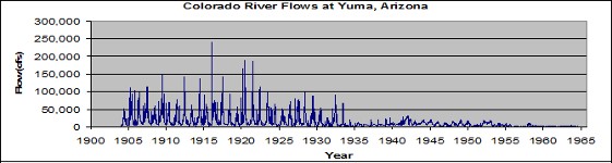
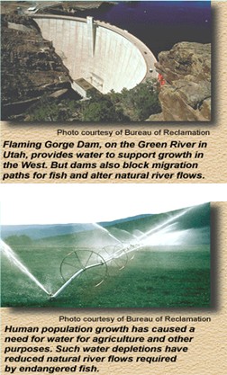
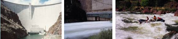
However we can understand that essentially all of the waters that entered the river stayed in the channel and flowed to the sea in an annual cycle that species have evolved to depend on. In the figure below, we can see the measured flows on the Colorado River near Yuma, Arizona. Notice how high the flows were prior to the construction of the Hoover Dam in 1935. After the construction of the dam, high flows from spring runoff could be captured and released to serve the demands of the rapidly growing agricultural districts and cities. Not only did these great feats of engineering provide water for people to use throughout the arid southwest, but it dramatically reduced the amount of water that was available for the native species that already depended on the river.
In addition to severely reducing the amount of water passing through channels, the construction of the major dams and reservoirs altered the timing of the flows. Since the one of the main purposes of building reservoirs is to retain water during high flow periods and release it during low flow periods, this often contradicts the biological patterns that various native species are adapted to. One significant example of this is the annual inundation of floodplains historically allowed vegetation to grow within them, which provided habitat for various animal species. While eliminating the potential for such large flooding events to occur protects communities and farms from becoming submerged, this comes at the cost of vast amounts of critical habitat.
Changes in Water Quality
The water quality of the Colorado River was also significantly altered by the construction of the numerous dams along the river. One characteristic of the river was the high rate of sediment transport that historically existed. Prior to the construction of these dams, the Colorado River transported massive amounts of sediment through milky colored water. This sediment movement provided nutrients for plant growth throughout the river channel and especially to the Delta region as the river entered the Sea of Cortez. Today much of the sediment is captured behind numerous dams along the course of the river’s path.
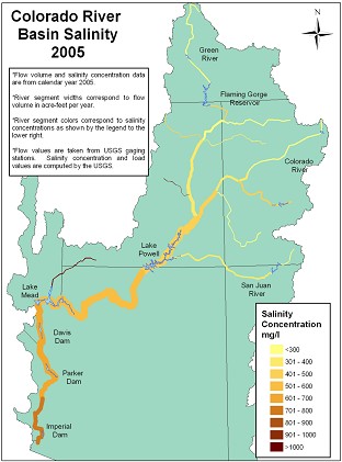
Concurrently an increase in salinity concentrations has occurred. This is due to excess water being used for irrigation purposes across the basin. As water gets diverted from the river and sprayed across the land, natural salts that occur in the soils are dissolved and return back to the river with return flows. This increased salt load, in combination with less water in the river due to diversions, has resulted in extremely high concentrations and expensive measures to remove salt from the river.
Another significant effect on the water quality of the Colorado River was a dramatic change in water temperatures downstream of the various dams. Prior to the construction of the reservoirs, high spring runoff of snowmelt would result in close to freezing water temperatures while the temperature of the flows in the summer would increase significantly due to the shallow depth. After construction of the reservoirs, flows were redistributed more uniformly throughout the year based on downstream demands and hydropower generation. Since temperatures deep in the reservoirs tend to be colder and releases through dam turbines draw water all year from these lower levels within the reservoirs, the flow in a river downstream of a dam tends to be steadier and the average temperature tends to be colder than would occur in a natural stream channel.
Impacts on Species
So what do these changes mean for native species? This is a complex question because some species can adapt while others cannot. Some major impacts that have been documented are:
Reduced flows causing reduction in critical floodplain habitat
Changing water levels from fluctuating reservoir releases stranding eggs and fish larvae
Increase in non-native fish species competing for food with and predation of native species
Reduction in native riparian vegetation and increases in non-native species vegetation, especially Salt Cedar
Water temperature reductions disturbing reproduction cycles
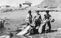
Reduction in flows result in increased salinity concentrations in the estuarine habitat in the Sea of Cortez, which has dramatically reduced the area suitable for breeding and egg laying of now endangered species such as the Totoaba and Vaquita porpoise
We will now explore some of the species that have suffered from changes in flows and water quality due to diversions and the construction of dams, and what we are doing and are not yet doing to reverse this trend.
Case Study #1: Upper Colorado Fish Recovery Program
Overview
The Upper Colorado River Basin, which is composed of the Colorado River and its tributaries upstream of Lake Powell, is home to 14 native fish species, 4 of which are now endangered. These 4 fish include the Colorado pikeminnow, razorback sucker, bonytail, and humpback chub. These species have evolved in the Colorado River basin and exist nowhere else on earth. The fish are now endangered because of human impacts on their habitat over the past 100 years. The two types of habitat alterations that appear to have had the greatest impact have been water development and introductions of non-native fish. Hundreds of dams, diversions, and other barriers have been constructed; river flows have been cut by a third; and more than 40 species of non-native fish have been introduced in the Upper Colorado River Basin.
Location
The Colorado River and its tributaries make up one of the world's most colorful river basins. From the high mountains of Wyoming and Colorado, the river drops more than two miles in elevation on its 1,700-mile journey to the Gulf of California. For long stretches, the river is bounded by red canyon walls. River flows fluctuate widely from season to season and from year to year, historically reaching peaks of nearly 400,000 cubic feet per second. It took tough, adaptable creatures to survive in this river system.
Native Fish Species in the Upper Colorado River Basin
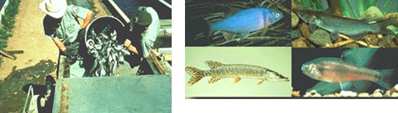
Only 14 species of fish are native to the Upper Colorado: the Colorado pikeminnow, bonytail, humpback chub, razorback sucker, Colorado River cutthroat trout, Rocky Mountain whitefish, roundtail chub, speckled dace, Kendall Warm Springs dace, flannelmouth sucker, mountain sucker, bluehead sucker, mottled sculpin, and the paiute sculpin. Click on the buttons to the right for more in-depth description of the 4 endangered species.
Colorado Pikeminnowm
Ptychocheilus Lucius
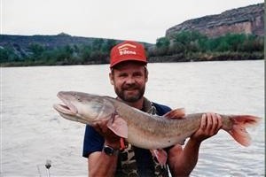
Description: The Colorado pikeminnow, also known as the Colorado squawfish, is the largest North American minnow. These fish have been known to reach six feet in length and 80 pounds in weight. Adult fish may be green-gray to bronze on their backs and silver to white along their sides and bottoms. During spawning, their fins can take on an orange hue.
Range: Historically, the pikeminnow occurred in great numbers throughout the Colorado River system from Green River in Wyoming to the Gulf of California in Mexico. In Colorado, they are currently found in the Green, Yampa, White, Colorado, Gunnison, San Juan, and Dolores rivers.
Habitat: The Colorado pikeminnow thrives in swift flowing muddy rivers with quiet, warm backwaters.
Diet: Colorado pikeminnow are primarily piscivorous (fish-eaters), but smaller individuals also eat insects and other invertebrates.
Reproduction: The species spawns during the spring and summer over riffle areas with gravel or cobble substrate. Eggs are randomly splayed onto the bottom and usually hatch in less than one week.
Endangered status: The Colorado pikeminnow is listed as threatened in Colorado and endangered federally. Dam construction and other water diversion projects along the Colorado River system has contributed to its decline. Dams lower water temperatures and block migration routes, hampering spawning of pikeminnow. The introduction of non-native bait minnows and stocking of predatory game fish species (such as northern pike, largemouth bass, sunfish, and catfish) are suspected to have contributed to their decline as well. Recovery actions are underway to remove non-native fish, construct bypasses around in-stream barriers, and restock pikeminnow into native habitat.
- Source: Colorado Division of Wildlife
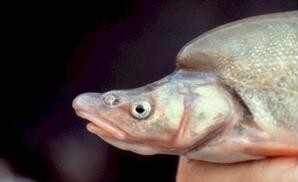
Razorback Sucker
Xyrauchen Texanus
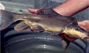
Description: The razorback sucker is a large, bronze to yellow fish that grows to a weight of about 15 pounds and has a sharp-edged keel behind the head. Breeding males turn gray-black with a bright orange belly.
Range: Originally widespread in the Colorado River system, wild populations were reduced to a small number of individuals in the Yampa, Colorado and Gunnison rivers in Colorado. Reproducing populations remain only in the middle Green River in Utah and in an off-channel pond in the Colorado River near Grand Junction. The razorback is most often found in quiet, muddy backwaters along the river.
Habitat: razorbacks are found in deep, clear to turbid waters of large rivers and some reservoirs over mud, sand or gravel.
Diet: Like most suckers, the razorback feeds on both plant and animal matter.
Reproduction: The razorback sucker spawns in the spring. Breeding males turn black up to the lateral line, with brilliant orange extending across the belly.
Endangered status: The razorback sucker is listed as endangered federally and in Colorado. Loss of large flood plain habitat and non-native fish predation are believed to be primary factors in the decline of this species. Since the monitoring program began in 1978, significant survival of young razorbacks into adulthood has not been documented. Restoration stocking of razorback is occurring in the Green, Colorado, Gunnison and San Juan rivers to develop and augment adult populations. Restoration of flooded bottomland habitats and non-native fish control are being conducted hand-in-hand to provide suitable nursery habitats for young razorback suckers.
- Source: Colorado Division of Wildlife
Bonytailm
Gila Elegans
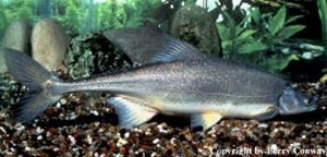
Description: This large chub is also a member of the minnow family. It’s similar to the humpback chub, but it has only a slight hump behind the head and a long, narrow tail. Adults are dark on top and light below. They are very dark in clear waters and pale in turbid waters. Bonytails can reach 24 inches in length. They have green-gray backs with lighter sides and white bellies. During breeding, males turn red-orange on the belly and paired fins. Their fins are large, slightly falcate. Dorsal fins typically have 10 rays, tail fins have 10 to 11 rays.
Range: Historically, bonytails were present in the Colorado River system, which includes the Yampa, Green, Colorado and Gunnison rivers. Today, there are no known populations in Colorado. They can be found in the Green River drainage in Utah and Mohave Reservoir on the Arizona-Nevada border.
Habitat: This fish typically lives in large, fast-flowing waterways of the Colorado River system. But their distribution and habitat status are largely unknown due to its rapid decline prior to research into its natural history.
Diet: Adult bonytail feed on terrestrial insects, zooplankton, algae and plant debris. Young feed mainly on aquatic insects.
Reproduction: Although bonytail spawning in the wild is now rare, the species does spawn in the spring and summer over gravel substrate. Many bonytail are now produced in fish hatcheries, with the offspring released into the wild when they are large enough to survive in the altered Colorado River system environment. Females produce between 1,000 and 17,000 eggs. Hatching occurs about nine hours after fertilization and swim-up begins generally 48 to 120 hours later. Survival rate of young fish is about 17 to 38 percent.
Endangered status: The bonytail is listed as endangered federally and in Colorado. Reasons for its decline are probably similar to the other endangered Colorado River fishes. The large-scale damming of the river has diminished available habitat. Damming and channeling not only change the speed, location and volume of water flow, the practices change the temperature and clarity of the water and block migration routes. Other threats to the bonytail have been the introduction of non-native fish that compete for food and habitat, and may prey on it or hybridize with it. The bonytail is extremely rare in Colorado and no self-sustaining population exist throughout the Colorado River basin.
- Source: Colorado Division of Wildlife
Humpback Chub
Gila Cypha - Source: Colorado Division of Wildlife
Description: The humpback chub is a remarkable member of the minnow family that is green to silver and white with an abrupt hump behind the head. They grow to about 18 inches in length.
Range: The historic range of the humpback is similar to the pikeminnow, occurring in great numbers throughout the Colorado River system from Green River in Wyoming to the Gulf of California in Mexico. Today, they can be found in deep, canyon-bound portions of the Colorado River system such as Black Rocks and Westwater canyons on the Colorado River and Yampa Canyon inside Dinosaur National Monument.
Habitat: The humpback prefers deep, fast-moving, turbid waters often associated with large boulders and steep cliffs.
Diet: Humpback chubs feed predominately on small aquatic insects, diatoms and filamentous algae.
Reproduction: Spawning occurs between April and July during high flows from snowmelt. During breeding, males develop red tinges on the venter and cheeks.
Endangered status: The humpback chub is listed as threatened in Colorado and endangered federally. The construction of dams and other water diversion projects have contributed to its decline. Such diversions lower water temperatures, which prevents spawning downstream, and block migration routes. Humpback populations appear to be recovering in Yampa, Desolation-Gray, Westwater and Cataract canyons, and in Black Rocks in the Upper Colorado River basin. Populations in the Grand Canyon and Little Colorado River in the Lower Colorado River basin are also fairing better. These populations are currently being monitored for abundance. Removal of non-native fish is occuring in Yampa Canyon to enhance survival of humpback chub. Actions being taken to recover humpback chub include boosting and protecting river flows in the spring, monitoring fish population numbers and managing stocking of non-native fish to avoid conflict with endangered fish recovery.
Upper Colorado Fish Recovery Program: Why Some Native Fish in the Upper Colorado River Basin are Endangered
Water Development
Human population growth since the turn of the century has created a significant demand for water and hydroelectric power in western states. To meet that demand, hundreds of water projects, including dams, canals, and irrigation projects, have been constructed on the Colorado River and its tributaries. Water projects have restricted the fish to about 25% of their former range and have blocked some of the spawning migration routes of the Colorado pikeminnow and other species. Also, tailwaters 6 to 20 miles downstream from dams can be as much as 15 degrees colder than the rare fishes' preferred habitat. Downstream of Lake Powell, dams have segmented the once free-flowing, silty, and warm waters of the Colorado River into a series of lakes connected by cold, clear waters.
The remaining habitat has been changed considerably. The number and size of life-supporting wetlands has been cut dramatically across the nation. According to a 1990 U.S. Fish and Wildlife Service Congressional report on wetlands, over the last 200 years Colorado has lost an estimated 50% of its wetlands; Utah has lost roughly 30%; and Wyoming about 38%. In the Upper Colorado River Basin, stream-side wetlands have been drained or cut off from the river by dikes, and many of the rivers' backwaters have disappeared. Young native fish have depended on these areas, which enabled them to grow significantly faster and which provided warmer, slower-moving water chock-full of microscopic food.
- Source: U.S. Fish and Wildlife Service
Upper Colorado Fish Recovery Program: Why Some Native Fish in the Upper Colorado River Basin are Endangered
Non-Native Fish
Introductions of non-native fish into rivers, lakes, and reservoirs also have taken a toll on the native fish. Historically, there were only 14 fish species in the Upper Colorado River Basin. Then in the late 1800s, private citizens and state and federal wildlife agencies began stocking non-native fish into lakes, reservoirs, and streams in the Colorado River drainage.
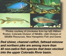
Now the 4 endangered fish have to compete with more than 40 non-native species.
Trout tend to inhabit colder stretches of river than the 4 endangered fish and generally are not considered a threat. But many of the non-native species, such as northern pike, channel catfish, red shiner and fathead minnow, are efficient predators that prey on the eggs and young of endangered fish.
Non-native fish also compete with native fish for food and space, often with greater success. Several studies have documented these effects. For example:
In some areas of the Upper Colorado River Basin, the percentage of native fish is quite low. At the confluence of the Colorado and Green Rivers in Utah, biologists have found that 95% of the fish species are non-native; only 5% of the fish that now exist in this part of the river basin are native.
At least four studies have shown predation by channel catfish, green sunfish, and carp on razorback sucker eggs and larvae.
In a study of predation on Colorado pikeminnow and various non-native fish, the largemouth bass showed a strong preference for native fish, eating twice as many young pikeminnow as red shiners and as much as 20 times the number of pikeminnow as green sunfish. (Largemouth bass, red shiners, and green sunfish are not native to the Colorado River basin.)
Young Colorado pikeminnow have been found in the stomachs of channel catfish collected in the Dolores River, even though pikeminnow are very rare in the area. Also, researchers as well as early settlers reported finding pikeminnow that had died trying to swallow channel catfish. Apparently, the barbs of the catfish make it difficult or impossible for pikeminnow to swallow and digest this non-native fish.
Utah State University researchers found that in the Duchesne River, 1- to 3-year-old Colorado pikeminnow constituted 5% of the diets of northern pike - a disproportionately high percentage, given that pikeminnow constitute a much smaller portion of the available food base in the river. Based on their findings, the researchers concluded that a single northern pike could consume more than 100 one year-old pikeminnow per year.
- Source: U.S. Fish and Wildlife Service
Upper Colorado Fish Recovery Program: Why Some Native Fish in the Upper Colorado River Basin are Endangered
Other Factors
Some portions of the Upper Colorado River Basin have high levels of selenium. Animals need this naturally occurring element in trace amounts but in larger concentrations, selenium can cause severe birth defects in wildlife. Researchers are conducting studies to determine if selenium is affecting the ability of endangered fish to survive and produce healthy offspring. Selenium is believed to increase due to agricultural irrigation runoff.
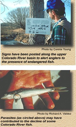
Some native fish have been killed by anglers who did not release the fish properly. Also, some anglers may prefer to catch northern pike, channel catfish, and other non-native sport fish they consider more desirable. After hooking a native fish, they may have tossed it on the riverbank to die.
n the mid-1960s, efforts were made to reduce native fish populations and make way for stocking non-native sport fish in Flaming Gorge and Navajo reservoirs. This was done with the use of rotenone, a substance extracted from the root of the derris plant. (Rotenone reduces fish populations by temporarily preventing fish from absorbing oxygen through their gills.) Following the use of rotenone, biologists found that although the total number of fish had dropped, the ratios of various species remained about the same. This led them to conclude there had been no lasting effect on the native fish species.
Other factors that may have contributed to the fishes' decline include pollution and parasites. Among the chubs, hybridization may also be a factor.
- Source: U.S. Fish and Wildlife Service
Upper Colorado Fish Recovery Program: Finding Solutions
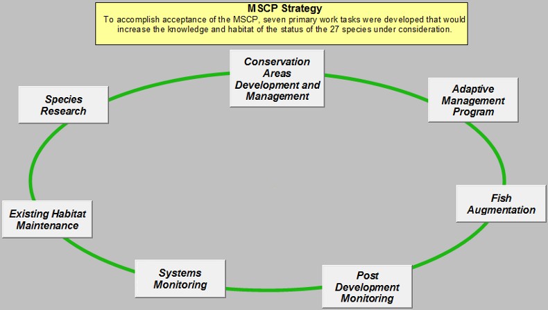
The Upper Colorado Fish Recovery Program has identified 7 major methods to try to restore the endangered species in the area of interest. Below you can explore each of these methods and consider how all these components are necessary to recover species that we have brought to the edge of extinction. These species will be considered recovered when there are self-sustaining populations of each fish species and when there is natural habitat to support them. -- Source: U.S. Fish and Wildlife Service
Designating 'critical habitat'
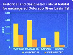
Under the Endangered Species Act, the U.S. Fish and Wildlife Service has primary responsibility to preserve not only threatened and endangered species, but also the natural resources on which they depend. In fulfilling this responsibility, in March 1994, the Department of the Interior designated 1,980 miles of the Colorado River as "critical habitat" for Colorado pikeminnow, razorback sucker, bonytail and humpback chub.
The areas are primarily federal lands and to a lesser extent tribal, state and private lands in portions of Colorado, Utah, New Mexico, Arizona, Nevada and California. The action was the outcome of a lawsuit by the Sierra Club Legal Defense Fund and a subsequent court order. Under certain circumstances the U.S. Fish and Wildlife Service now has more authority to protect the waters and land that are considered critical to the fishes' recovery.
These fish have similar habitat requirements and historically lived in the same rivers. Therefore, the areas designated for each of the four fish overlap. The 1,980 miles of designated critical habitat includes 1,724 miles of river reaches for the razorback sucker, which is 49 percent of its historical range; 1,148 miles for the Colorado pikeminnow, which is 29 percent of its historical range; 379 miles for the humpback chub, which comes to 28 percent of its historical range; and 312 miles for the bonytail, which amounts to only 14 percent of its historical range.
Providing adequate stream flows
This aspect of endangered fish recovery involves acquiring and protecting adequate stream flows and altering operations of federal dams to re-create more natural flow patterns.
This strategy seeks to mimic more natural flow patterns, providing high flows during natural spring runoff, and lower, more stable flows the rest of the year. Large volumes of water carve out the riverside nooks and crannies, or "backwaters and side channels," that endangered fish need to feed, grow and survive.
Improving the river habitat
One strategy being used to improve river habitat is to make river-side flood plain property accessible to endangered fish. In some cases, this involves breaking down or removing dikes along the river to allow the fish to swim into the wetland. In situations where no dikes exist, the approach may be to protect the property from development, ensuring it will continue to be available to the fish.
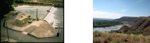
River habitat also is being improved by building fish passageways and ladders, such as the one shown at left, around dams and other instream barriers, enabling endangered fish to migrate upstream and down.
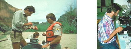
Conducting research
Researchers from various universities and state and federal agencies independently began gathering information on these fish in the 1960s. In 1979, the U. S. Fish and Wildlife Service's Colorado River Fisheries Project began coordinating research on endangered fish. These early research projects provided background information necessary to guide current research studies.
Since 1988, all research and capital construction projects in the Upper Colorado River Basin have been coordinated by the Upper Colorado River Endangered Fish Recovery Program.
Managing nonnative fish species
The Upper Colorado River Endangered Fish Recovery Program is working to recover endangered fish while also working to minimize the impact on non-native sport fishing. In general, stocking nonnative fish species in the upper Colorado River basin has been confined to areas where there is little potential conflict with endangered fish. But trout tend to live in different parts of the river, and are not considered competitors with endangered fish. Trout are cold-water fish that prefer temperatures 10 to 15 degrees cooler than those in downstream sections of the river where endangered fish are found.
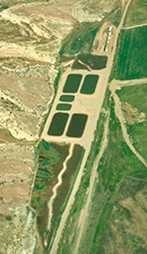
Hatcheries and Stocking
Hatchery facilities and ponds for raising endangered fish now are available in five different sites in Utah and Colorado. Each of these facilities was established to meet specific objectives necessary to recover endangered Colorado River fish. They all follow these guidelines for raising the fish:
To increase the likelihood that the hatchery-raised endangered fish will survive and successfully reproduce in the wild, scientists are working to raise fish whose behavior and genetic background closely match that of wild fish.
Whenever possible, the adult fish used as brood stock have come directly from the wild.
When producing offspring, a large number of adult fish are bred; this technique maintains the genetic diversity - and hopefully adaptability - of the young.
Refuge ponds are being used to maintain endangered fish from a variety of rivers, providing insurance against extinction from a catastrophic event, such as an oil or chemical spill in the river.
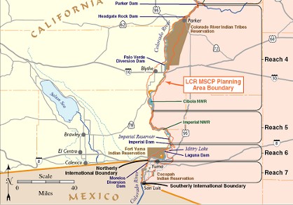
Case Study #2: Lower Colorado River Multiple Species Conservation Program
Overview
The Lower Colorado River Multi-Species Conservation Program (LCR MSCP) is a coordinated, comprehensive, long-term multi-agency effort to conserve and work towards the recovery of endangered species, and protect and maintain wildlife habitat on the Lower Colorado River.
The MSCP's purposes are:
protect the Lower Colorado River environment while ensuring the certainty of existing river water and power operations;
address the needs of threatened and endangered wildlife under the Endangered Species Act (ESA); and
reduce the likelihood of listing additional species along the Lower Colorado River.
The program was developed and is being implemented and funded by a partnership of state, federal, and other public and private stakeholders in Arizona, California, and Nevada with interests in managing the water and related resources of the Lower Colorado River. The impetus for the creation of the LCR MSCP was the recognition by federal and non-federal participants of the potential for their activities to affect species listed as threatened or endangered under the ESA, as well as designated critical habitat along the Lower Colorado River. The participants agreed to form a partnership to develop and implement a long-term endangered species compliance and management program for the historic floodplain of the Lower Colorado River.
Multiple Species Conservation Program: Location
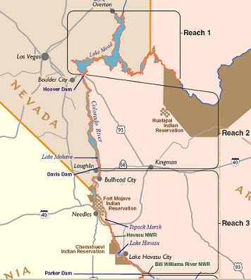
The LCR MSCP covers areas up to and including the full-pool elevations of Lakes Mead, Mohave, and Havasu and the historical floodplain of the Colorado River from Lake Mead to the United States-Mexico Southerly International Boundary, a distance of about 400 river miles. Conservation measures currently focus on the area from Hoover Dam to the border, but may include Grand Canyon in the future.
MSCP Goals
Conserve habitat and work toward the recovery of threatened and endangered species as well as reduce the likelihood of additional species being listed;
Accommodate present water diversions and power production and optimize opportunities for future water and power development, to the extent consistent the law
Provide the basis for incidental take authorizations
The driving force behind the LCR MSCP is multi-faceted. Notice that the goals of the LCR MSCP are not only to recover threatened and endangered species and to avoid additional species from becoming threatened or endangered during the 50 year term of the LCR MSCP; in addition, the goals explicitly focus on allowing present and future water and power uses. Water users and power production companies have a vested interest in finding ways to conduct business while avoiding violations of laws that protect endangered and threatened species. Furthermore, they also want to avoid new species from becoming threatened or endangered because the Endangered Species Act (ESA) could potentially affect their future ability to use and control Colorado River water.
For water and power users, the LCR MSCP is a trade-off. Under the ESA, activities that impact endangered and threatened species can be restricted to protect the viability of the species. Therefore making any modifications to the operation of the Colorado River requires an evaluation of how that modification might impact those species. Furthermore, if a change to the Colorado River results in a negative impact to a threatened or endangered species, then it could be restricted from occurring due to the ESA regulations. However, organizations can pro-actively apply to the U.S Fish and Wildlife Service to make modifications to the ecosystem that may damage habitat for threatened species. If certain criteria are met by the applicants to the U.S Fish and Wildlife Service then these modifications can be allowed to take place.
The purpose of the MSCP then is to analyze the impacts of and mitigate for a wide range of actions that currently affect or may affect many species in the river. With this lumped approach, impact statements for individual modifications could be avoided. Activities covered by the Habitat Conservation Plan (HCP) include all non-federal actions involved in:
water diversions and returns of up to 7.5 million acre-feet per year from existing facilities;
diversions and returns for any surplus waters;
future changes in points of diversion of up to 1.574 million acre-feet per year;
implementation of the LCR MSCP, including mitigation measures;
many present and future flow- and non-flow-related non-federal actions or projects; and
demand for and receipt of hydropower.
The LCR MSCP Habitat Conservation Plan (HCP) states: This HCP is intended to meet all the regulatory requirements necessary for the USFWS to issue a section 10(a)(1)(B) permit to allow incidental take of threatened and endangered species affected by specified non-Federal agency activities (covered activities) within the LCR MSCP planning area (Multiple Species Conservation Plan – Final Habitat Conservation Plan, 2004).
Multiple Species Conservation Program: Applicants
The List of Applicants includes a variety of entities with interests in the Colorado River.
California
Bard Water District
Coachella Valley Water District
Colorado River Board of California
Imperial Irrigation District
The Metropolitan Water District of Southern California
Palo Verde Irrigation District
San Diego County Water Authority
Southern California Public Power Authority
Arizona
Arizona Department of Water Resources
Arizona Game and Fish Department
Arizona Power Authority
Central Arizona Water Conservation District
Mohave County Water Authority
North Gila Valley Irrigation and Drainage District
Salt River Project Agricultural Improvement and Power District
Wellton-Mohawk Irrigation and Drainage District
Yuma County Water Users Association
Yuma Mesa Irrigation and Drainage District
Yuma Irrigation District
Nevada
Basic Water Company
Colorado River Commission of Nevada
Nevada Department of Wildlife
Southern Nevada Water Authority
In addition, several federal entities are involved seeking ESA coverage for various activities including:
Bureau of Reclamationy
Western Area Power Administration
National Park Service
Bureau of Indian Affairs
The MSCP is managed and implement by two entities including:
Program Manger employed by the Bureau of Reclamation
A Steering Committee whose members are divided into several participating groups: Federal, Arizona, California, Nevada, Native American, Conservation, and Other Interested Parties
Particular projects to create or restore habitat are outlined in the Habitat Conservation Plan and funding is shared between federal and state sources. Numerous stakeholder meetings throughout the Lower Colorado Region were held during the development of the HCP, along with coordination with scientific review panels, to identify the specific projects that are included in the HCP.
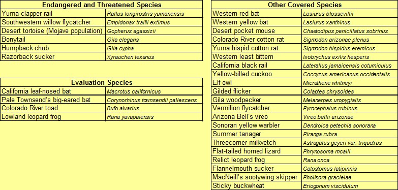
Multiple Species Conservation Program: Species Evaluated
Originally 149 species were evaluated and 27 were chosen for the “Incidental Take” permit as defined by the ESA. Six species of these species are currently considered federally threatened or endangered, while 21 other species are listed as endangered under specific state laws. Four evaluation species were also evaluated that are not currently listed, but may become so during the 50-year term of the LCR MSCP.
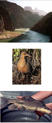
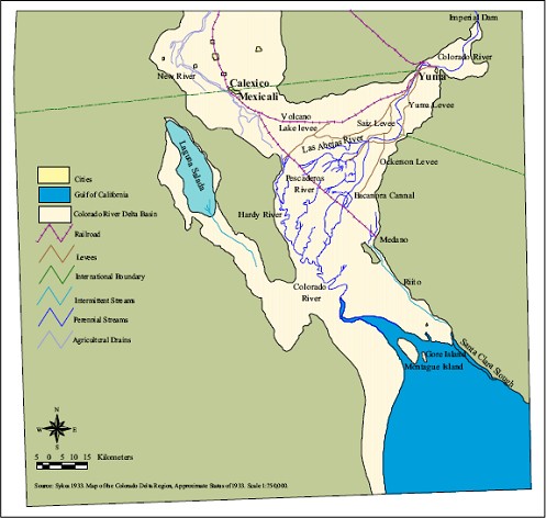
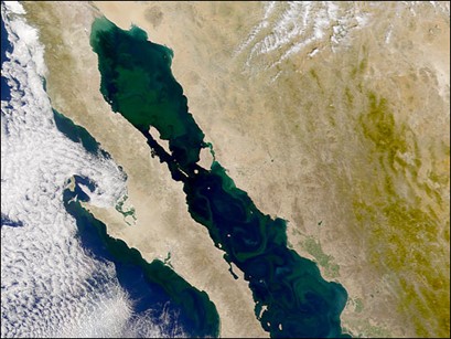
Case Study #3: The Colorado River Delta
Perhaps one of the most dramatically changed ecosystems of the Colorado River is the last reach before it enters the Gulf of California. At its southernmost extent, the River forms the Colorado River Delta. Prior to the construction of the major dams, the Colorado River fed one of the greatest desert estuaries in the world with annual flood flows that nourished a complex mosaic of riparian, freshwater, brackish, and tidal wetlands that covered 1,930,000 acres (780,000 hectare). In the vast Sonoran Desert, the silt and nutrients that poured through the Delta provided a rich habitat for abundant wildlife including nesting and feeding grounds for several bird species and spawning habitat for fish and crustaceans. Following such abundant food sources, mammals also used the Delta to thrive in a harsh environment.
Base Map
Historic Delta Vegetation
Current Delta Vegetation
The Colorado River Delta (Continued)
Today conditions in the Delta are different. Two major reservoirs and dozens of smaller reservoirs and diversion dams keep the water from reaching this critical ecosystem. All the waters that are currently released from the reservoirs are intended for consumption. Only when the reservoirs are full and releases must be made for flood control is there any significant opportunity for water to reach the Delta.
Other Sources?
Some water does reach the Delta, but in very small quantities. Return flows from irrigation of agricultural fields in the Mexicali Valley fields seep back into the Delta region providing a precarious subsistence for the remaining ecosystem. Although this agricultural wastewater can change the ecosystem health by introducing fertilizers, insecticides, and elevated levels of other pollutants such as selenium, these discharges are the only reliable source the delta currently has to survive.
One other source of water currently exists. The Cienega de Santa Clara is the major marsh wetland in the eastern region of the Delta. This region is supplied by agricultural wastewater pumped from the Wellton-Mohawk Irrigation District and discharged through a concrete canal to the Southern International Boundary. However this lifeline to the Delta will potentially be severed if a desalination plant at Yuma Arizona is put into operation.
The Colorado River Delta (Continued)
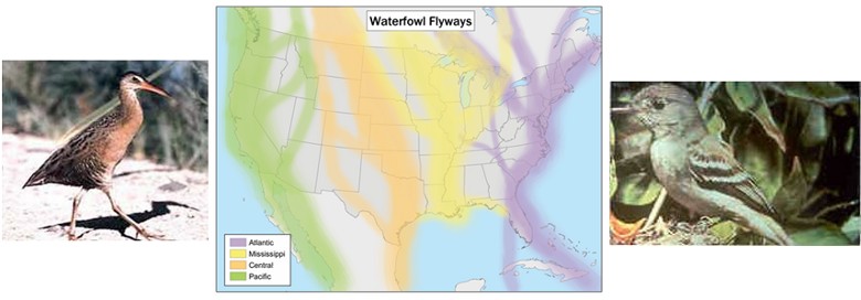
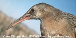
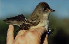
Although the Colorado River Delta has been dramatically transformed, it still provides a critical resource. Numerous migratory birds use the Delta as stopping point along the Pacific Flyway. In addition, various endangered species use the Colorado River Delta as their habitat for all or part of the year. Bird species include the Yuma Clapper Rail and the Willow Flycatcher. These species thrive in the vegetation and marshes of the Delta.
Yuma Clapper Rail
General Information: A marsh bird the size of a chicken, the Yuma Clapper Rail is gray-brown above and buffy-cinnamon below and has brownish-gray cheeks and flanks barred with black and white. Its somewhat orange bill is long and slightly down-curved.
Reproductive Strategy: Rails establish pair bonds and territories in March-May, with nesting in May through June. One clutch is born per year. Juveniles are ready to breed the spring following their birth.
Food Habits: Primarily crayfish, with small fish, frogs, and aquatic invertebrates also taken.
Habitat Requirements: Fresh-water marshes dominated by cattail or bulrush. Early successional marshes with little residual vegetation may be preferred. Habitat should be in a mosaic of vegetated areas interspersed with shallow (less than 12") open water areas. Minimum size of suitable habitats is unclear, but have been found in areas as small as 2-3 acres depending on the quality of the mosaic.
Movement / Home Range: Most individuals do not migrate, but have minor seasonal changes in their activity areas. Juveniles do disperse to nearby habitats. The recent extension of the range north along the lower Colorado River implies that rails are capable of longer distance movements, although the presence of scattered habitat patches for resting is likely important. Seasonal availablity of food may be important factor in the need to migrate greater distances.
Other Important threats: loss of marsh habitat through dredging/filling activities, decline in quality of marsh habitat due to build-up residual vegetation (dead stems and leaves of cattails or bulrush) that clogs movement through the vegetation, and selenium contamination of the prey base.
Southwestern Willow Flycatcher
Habitat: The Southwestern Willow Flycatcher occurs in dense riparian habitats along streams, rivers, and other wetlands. At low elevations, the flycatcher breeds in stands of dense cottonwood, willow, and tamarisk thickets, as well as other lush woodland areas near water.3 At higher elevations, it occurs in pure stands of Geyer willow.3 The destruction of riparian habitats has caused a severe decline in the populations of the southwestern willow flycatcher.4 This sub-species exists only in fragmented and scattered locations throughout the state.
Range: Historically, the breeding range reached from southern California, southern Nevada, southern Utah, Arizona, New Mexico, western Texas, southwestern Colorado, and northwestern Mexico.4 The flycatcher is a migratory bird with little known about its winter range. It is currently thought that it winters in Mexico, Central America, and northern South America. Currently, the breeding range for the flycatcher is similar to the historic range, though much of the riparian habitat in the southwest has been destroyed due to agricultural and urban development.
Diet: The Southwestern Willow Flycatcher is an insectivore, taking insects from the air, or picking them from the foliage.
Reproduction: The Southwestern Willow Flycatcher is present on breeding grounds by mid-May. By late May, nests are built, usually in a branched tree fork near the water. Typically, three eggs are laid and then incubated for 12¬13 days. Breeding success is heavily affected by predation and brown-headed cowbird parasitism.
Status: The Southwestern Willow Flycatcher was declared endangered March 29, 1995, under the Endangered Species Act of 1973. The species does have an approved recovery plan and designated critical habitat.
The Colorado River Delta (Continued)
During the 20th century, river flows into the Delta have been reduced nearly 75%, from an annual average of 16.7 million acre-feet (20.7 x 10⁹ m3) between 1896 to 1921, to an annual average of 4.2 million acre-feet (5.2 x 10⁹ m3) between 1984 and 1999. This reduction in water has resulted in major changes to the Delta: less silt, fewer nutrients, higher salinity, and higher concentrations of pollutants.
Erosion, rather than accretion, is now the dominant physical process in the Delta, a highly unusual condition for a river Delta. Like other river deltas at risk, such as the Nile, the Colorado’s Delta has actually begun to decrease in size. The loss of freshwater flows to the Delta over the past century has reduced Delta wetlands to about 5% of their original extent, and non-native species have compromised the ecological health of much of what remains. Stress on ecosystems also has allowed invasive plants to choke out native species along Colorado River riparian areas. Native forests of cottonwood and willow have yielded to sand and mudflats dominated by the nonnative tamarisk (also known as salt cedar), arrowweed, and iodinebush, a transformation that has decreased the habitat value of the riparian forest (Briggs el al., 2004; EDF, 1999).
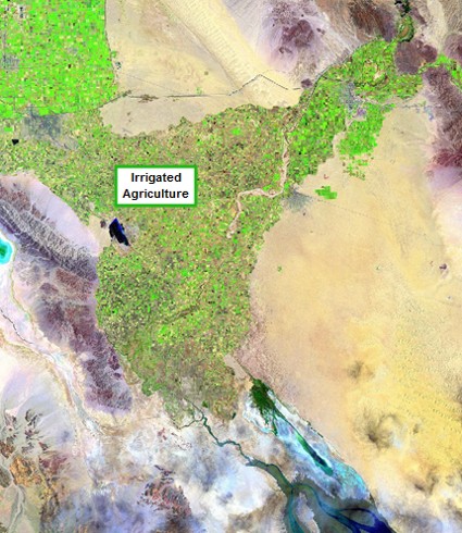
The rich soils of the Delta are now used extensively for agriculture and levees have been constructed to constrain the flood flows of the Colorado. Although the overall landscape has been transformed, the small amount of vegetation that remains between is a critical resource for the current ecosystem.
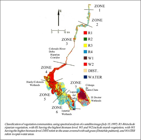
Current Delta Vegetation
The Colorado River Delta (Continued)
Three general regions can be identified within the Delta region:
The northernmost region (Zones 1-3) is constrained between the levees and provides a rich riparian corridor.
Two major wetland zones exist in the Delta region. Near the confluence with the Rio Hardy, an extensive wetland area provides cover and nesting for many of the species that thrive in the Delta region (Zones 4, 5). In addition a major wetland habitat exists to the east of the main channel which includes the Cienega de Santa Clara, El Doctor Wetlands and Laguna del Indio (Zone 7).
The southernmost region is also an intertidal wetland heavily influenced by the saltwater reaching northward into the Delta.
The Colorado River Delta (Continued)
The Delta needs water to sustain its limited ecosystem. A constant baseflow and occasional flood flows are necessary to both maintain the riparian vegetation and inundate the floodplain between the levees. In addition, regular flows would keep the nutrients cycling through the Delta and flush the salt that concentrates on the banks through evaporation.
Since all the water is typically diverted upstream of the Delta, only incidental flood flows currently reach the Delta. However if additional water were allowed to reach the Delta through intentional releases from the upstream reservoirs, significant benefits could result for the ecosystem.
Whose Responsibility is the Delta?
We know that most of the destruction of the Delta is caused by water management decisions in the United States, but the fact that most of the Delta exists in Mexico makes it difficult to resolve. The U.S. federal government claims that its responsibility for species protection generally ends at the border, so even the Endangered Species Act doesn’t require any programs such as the Lower Colorado Multiple Species Conservation Program to incorporate the Delta into its planning process. Mexico, on the other hand, has limited water and infrastructure to manage flows and believes much of the responsibility exists with the United States. An unfortunate political line has pushed a critical habitat to the brink of extinction.
Protection Designation
The Gulf of California lies within the jurisdictional boundaries of Mexico and its states of Baja California and Sonora. In 1974, the Mexican government designated portions of the upper Gulf and lower Colorado River Delta as a reserve zone.
The United Nations Educational, Scientific, and Cultural Organization (UNESCO) designated over 3 million acres (12,000 km²) of upper Gulf of California and the Colorado River Delta as a Biosphere Reserve in June 1993. Within this 3 million acres (12,000 km²), over 1 million acres (4,000 km²) nearest the Colorado River Delta are designated as the Reserve core area, with the remaining 2 million acres (8,000 km²) of open water and shoreline designated as a buffer area.
The Colorado River Delta (Continued)
The questions become:
How much baseflow is needed?
How much flood flow is needed?
How frequently is a flood flow needed?
Where could this water come from?
How could this water be obtained?
Modeling the Delta Habitat
To understand the effects that flows might have on the Delta, we can construct a model of the vegetation and the response to these increased flows. Let’s start out with the major factors that we know:
The vegetation in the Delta can be simplified to three zones:
Riparian Corridor
Wetland Area
Tidal Wetland/Estuary Area
We know that increasing flow in the Delta allows increased growth of vegetation.
We also know that constant flows increase the ratio of native to non-native species.
Delta Simulator
Download the Excel-based interactive and jump to the end of the Unit to explore the Delta Simulator
Luecke, D, J.Pitt, C. Congdon, E. Glenn, C. Valdes-Casillas, and M. Briggs. 1999. A Delta Once More: Restoring Wetland and Riparian Habitat in the Colorado River Delta. http://www.edf.org/documents/425_Delta.pdf
Luecke, D, J.Pitt, C. Congdon, E. Glenn, C. Valdes-Casillas, and M. Briggs. 1999. A Delta Once More: Restoring Wetland and Riparian Habitat in the Colorado River Delta. http://www.edf.org/documents/425_Delta.pdf


